

 Tweet
Tweet
It's been a side-project of mine for some time in developing a trade-map of the valley, based on mine and James' observations and the data in the wiki. Some of you might recall a nice looking map of the peninsula I released into Character Artwork a while back.
Recent discussion on Locate Creature has made me realize that perhaps a unified view of the scale of the valley might benefit discussion on distances and travel times and the like, and as such I present some of my work-in-progress and reasoning. This is all data I have attempted to gather from various sources and not currently validated by DM, but hopefully can be refined for everyone's benefit.
Scale:
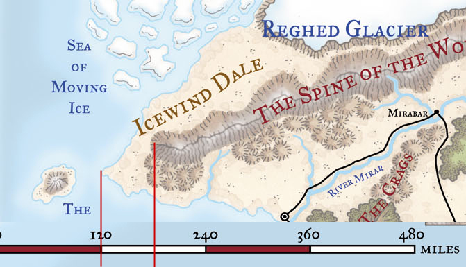
From my calculations, Sundren is 60 miles wide, based on analysis of the official WOTC 3.0 map of Faerun.
Secondly, using Doubt's rough map of post-sundering trade, I developed a pretty version, using an isogrid with a scale of roughly 60 units across the length of the peninsula:
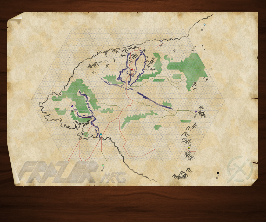
Lastly, for simple error-checking of the roughly correct scale, I counted along the roads (red lines are active trade routes, green lines are just roads, green triangles are >50% forested area) based on the sign on the Pioneer's Way marking the distance between the Gate of the Sunderer and Sundren City, which proudly proclaims Sundren City to be 40km. I'm somewhat expecting that there would be fudge-distance on both ends, as one would be going from a distance from the Gate to the edge of the city sprawl. counting along the road ends up at 48 (miles) from the intersection at Sundren City to the yellow pin marking the Gate of the Sunderer. Which comes out at 77ish kilometers, but for the purposes of scale and system, sticking to miles seems more appropriate (D&D only ever gives overland distances in Miles-per-time, for example). A fudge factor of 4 miles at either end doesn't seem unreasonable to me either, combined with the fact that I doubt the roads are precisely accurate.
Based on this map, it becomes possible to make various assessments of travel distance and time, assuming a standard speed of 30 feet per round(3 MPH/24 MPD), time rounded down to the nearest hour (assume you hustle when you get close):
Gate to Second Wind (estimated): . 25-30 miles by road - one day's travel (convenient, eh?)
Gate to Crossroads: . . . . . . . . . . . 40 miles - one day + 6 hours
Crossroads to Port Avanthyr: . . . . . 10 miles - 3 hours
Gate to Avanthyr: . . . . . . . . . . . . 50 miles - 2 days
Crossroads to Sestra: . . . . . . . . . . 17 miles - 6 hours
Gate to Sestra: . . . . . . . . . . . . . . 57 miles - 2 days + 3 hours
Avanthyr to Sestra: . . . . . . . . . . . 17 miles - 6 hours
Crossroads to Mirakus Post: . . . . . . 21 miles - 7 hours
Gate to Mirakus: . . . . . . . . . . . . . 61 miles - 2 days + 4 hours
Avanthyr to Mirakus: . . . . . . . . . . 21 miles - 7 hours
Sestra to Mirakus: . . . . . . . . . . . . 18 miles - 6 hours
Crossroads to Exigo Tradepost: . . . . 4 miles - 1 hour
Crossroads to The Pit (est.): . . . . . . 9 miles - 3 hours
Pit (est.) to Aquor: . . . . . . . . . . . . 12 miles - 4 hours
Crossroads to Aquor: . . . . . . . . . . . 21 miles - 7 hours
Gate to Aquor: . . . . . . . . . . . . . . . 61 miles - 2 days + 4 hours
Avanthyr to Aquor: . . . . . . . . . . . . 31 miles - 1 day + 2 hours
Sestra to Aquor: . . . . . . . . . . . . . . 37 miles - 1 day + 4 hours
Mirakus to Aquor: . . . . . . . . . . . . . 42 miles - 1 day + 6 hours
Mirakus to Schild: . . . . . . . . . . . . . 57 miles - 2 days + 3 hours
Exigo Tradepost to Abandoned Legion Fort (Viridale): 12 miles - 4 hours
Teleport: . . . . . . . . . . . . . . . . . . 100 miles per caster level, +/- 100% - 4 seconds + (misplacement/3) hours
Greater Teleport: . . . . . . . . . . . . . . Effectively infinite - 4 seconds
*For an unencumbered light horse (48 mi/day), divide by times by two.
**For an unencumbered heavy horse (40 mi/day), divide times by one-point-six.
***For a cart or wagon (16 mi/day), multiply times by one-point-three.
Whurest is currently shown at 22 miles out, but that is both a guess and through snowy and mountainous terrain, so at least a couple days from Aquor to Whurest Hold.
Not even going to try to calculate the distances to Arbiter's Stand, Argyle, or the Necropolis, since I only have a fixed location on one of those, and it has multiple paths to get to it (plus terrain means cutting across the Sharahan Hills closes the distance dramatically).
You guys are generally smart cookies and would be able to calculate your favorite vampire- and orc-ridden strolls on your own, I presume.
Faction territorial range is not yet included, though I do intend to. I've got a draft of the import and export of goods and their transport, but that really isn't applicable here. I also haven't labeled my axises yet, because it's an isogrid and standard (x,y) dosent cut it; (w,x,y) might though.
Thoughts, opinions, and prospective alterations would be greatly appreciated.
Recent discussion on Locate Creature has made me realize that perhaps a unified view of the scale of the valley might benefit discussion on distances and travel times and the like, and as such I present some of my work-in-progress and reasoning. This is all data I have attempted to gather from various sources and not currently validated by DM, but hopefully can be refined for everyone's benefit.
Scale:
From my calculations, Sundren is 60 miles wide, based on analysis of the official WOTC 3.0 map of Faerun.
Secondly, using Doubt's rough map of post-sundering trade, I developed a pretty version, using an isogrid with a scale of roughly 60 units across the length of the peninsula:
Lastly, for simple error-checking of the roughly correct scale, I counted along the roads (red lines are active trade routes, green lines are just roads, green triangles are >50% forested area) based on the sign on the Pioneer's Way marking the distance between the Gate of the Sunderer and Sundren City, which proudly proclaims Sundren City to be 40km. I'm somewhat expecting that there would be fudge-distance on both ends, as one would be going from a distance from the Gate to the edge of the city sprawl. counting along the road ends up at 48 (miles) from the intersection at Sundren City to the yellow pin marking the Gate of the Sunderer. Which comes out at 77ish kilometers, but for the purposes of scale and system, sticking to miles seems more appropriate (D&D only ever gives overland distances in Miles-per-time, for example). A fudge factor of 4 miles at either end doesn't seem unreasonable to me either, combined with the fact that I doubt the roads are precisely accurate.
Based on this map, it becomes possible to make various assessments of travel distance and time, assuming a standard speed of 30 feet per round(3 MPH/24 MPD), time rounded down to the nearest hour (assume you hustle when you get close):
Gate to Second Wind (estimated): . 25-30 miles by road - one day's travel (convenient, eh?)
Gate to Crossroads: . . . . . . . . . . . 40 miles - one day + 6 hours
Crossroads to Port Avanthyr: . . . . . 10 miles - 3 hours
Gate to Avanthyr: . . . . . . . . . . . . 50 miles - 2 days
Crossroads to Sestra: . . . . . . . . . . 17 miles - 6 hours
Gate to Sestra: . . . . . . . . . . . . . . 57 miles - 2 days + 3 hours
Avanthyr to Sestra: . . . . . . . . . . . 17 miles - 6 hours
Crossroads to Mirakus Post: . . . . . . 21 miles - 7 hours
Gate to Mirakus: . . . . . . . . . . . . . 61 miles - 2 days + 4 hours
Avanthyr to Mirakus: . . . . . . . . . . 21 miles - 7 hours
Sestra to Mirakus: . . . . . . . . . . . . 18 miles - 6 hours
Crossroads to Exigo Tradepost: . . . . 4 miles - 1 hour
Crossroads to The Pit (est.): . . . . . . 9 miles - 3 hours
Pit (est.) to Aquor: . . . . . . . . . . . . 12 miles - 4 hours
Crossroads to Aquor: . . . . . . . . . . . 21 miles - 7 hours
Gate to Aquor: . . . . . . . . . . . . . . . 61 miles - 2 days + 4 hours
Avanthyr to Aquor: . . . . . . . . . . . . 31 miles - 1 day + 2 hours
Sestra to Aquor: . . . . . . . . . . . . . . 37 miles - 1 day + 4 hours
Mirakus to Aquor: . . . . . . . . . . . . . 42 miles - 1 day + 6 hours
Mirakus to Schild: . . . . . . . . . . . . . 57 miles - 2 days + 3 hours
Exigo Tradepost to Abandoned Legion Fort (Viridale): 12 miles - 4 hours
Teleport: . . . . . . . . . . . . . . . . . . 100 miles per caster level, +/- 100% - 4 seconds + (misplacement/3) hours
Greater Teleport: . . . . . . . . . . . . . . Effectively infinite - 4 seconds
*For an unencumbered light horse (48 mi/day), divide by times by two.
**For an unencumbered heavy horse (40 mi/day), divide times by one-point-six.
***For a cart or wagon (16 mi/day), multiply times by one-point-three.
Whurest is currently shown at 22 miles out, but that is both a guess and through snowy and mountainous terrain, so at least a couple days from Aquor to Whurest Hold.
Not even going to try to calculate the distances to Arbiter's Stand, Argyle, or the Necropolis, since I only have a fixed location on one of those, and it has multiple paths to get to it (plus terrain means cutting across the Sharahan Hills closes the distance dramatically).
You guys are generally smart cookies and would be able to calculate your favorite vampire- and orc-ridden strolls on your own, I presume.
Faction territorial range is not yet included, though I do intend to. I've got a draft of the import and export of goods and their transport, but that really isn't applicable here. I also haven't labeled my axises yet, because it's an isogrid and standard (x,y) dosent cut it; (w,x,y) might though.
Thoughts, opinions, and prospective alterations would be greatly appreciated.


Comment